This website uses cookies so that we can provide you with the best user experience possible. Cookie information is stored in your browser and performs functions such as recognising you when you return to our website and helping our team to understand which sections of the website you find most interesting and useful.
Ring of Fire, Northern Ontario, Canada | 100% Owned by MetalQuest Mining
Quick Facts
- 1,094 contiguous mining claim cells covering approximately 22,000 hectares (54,360 acres) in the Ring of Fire, Northern Ontario
- 100% owned by MetalQuest Mining Inc., acquired by staking in January 2026
- Situated on the western margin of the Fishtrap Intrusive Complex, within a volcanic-intrusive belt considered prospective for VMS and Ni-Cu-PGM mineralization
- Previous helicopter-borne VTEM and magnetic surveys outlined numerous electromagnetic conductors across the property, many of which remain untested by drilling
- Large portions of the property remain underexplored, with multiple conductive trends and favourable stratigraphic horizons yet to be systematically evaluated
- MQM’s second Ring of Fire acquisition, complementing the previously acquired ROF-1 Project
Project Overview
MetalQuest Mining Inc. (TSX: MQM) acquired the Fishhook Polymetallic Project in January 2026 through staking, securing approximately 1,094 contiguous mining claim cells covering ~22,000 hectares (54,360 acres) in the Ring of Fire region of northern Ontario. The Fishhook Polymetallic Project is a VMS and nickel-copper-platinum group metal (Ni-Cu-PGM) exploration property and represents MQM’s second Ring of Fire acquisition, complementing the previously acquired ROF-1 Project.
The Fishhook Polymetallic Project is situated on the western margin of the Fishtrap Intrusive Complex, within the same regional volcanic-intrusive belt that hosts several significant mineral discoveries in the Ring of Fire. The large, continuous land package captures prospective volcanic stratigraphy, intrusive contacts, and multiple conductive trends identified by historical airborne geophysical surveys.
The acquisition reflects MQM’s strategy of securing large, underexplored land positions early, ahead of the next cycle of sustained exploration in the Ring of Fire. The scale of the project provides MetalQuest shareholders with multiple potential pathways for value creation, including staged exploration, data-driven target advancement, and long-term strategic optionality as regional activity continues to evolve.
Location & Access
The Fishhook Polymetallic Project is located in Northern Ontario’s Ring of Fire geological corridor, within the James Bay Lowlands. The project is situated on the western margin of the Fishtrap Intrusive Complex, within the same broader geological corridor that hosts multiple significant mineral discoveries in the district.
Access to the Ring of Fire has historically been limited to seasonal air and winter road access. The Ontario and federal governments have committed to advancing infrastructure in the region, including an all-season road corridor, with construction targeted to commence as early as August 2026. In late 2025, the Government of Ontario and the Government of Canada announced a cooperation agreement aimed at streamlining regulatory processes and accelerating major infrastructure projects associated with the Ring of Fire, with implementation progressing into 2026. This improving infrastructure backdrop is expected to significantly enhance access for exploration and future development activities across the district.
Property & Ownership
The Fishhook Polymetallic Project comprises 1,094 contiguous mining claim cells covering approximately 22,000 hectares (54,360 acres), acquired by staking and 100% owned by MetalQuest Mining Inc. The project is MQM’s second Ring of Fire asset and forms a key component of the Company’s growing multi-project district strategy. MetalQuest continues to evaluate additional opportunities in the Ring of Fire, with further updates to be provided as developments occur.
Regional Geology: The Ring of Fire
The Ring of Fire is a world-class critical mineral district located in the James Bay Lowlands of Northern Ontario. It is underlain by the McFaulds Lake Greenstone Belt, a sequence that host multiple styles of mineralization, including magmatic nickel-copper-PGE deposits, chromite deposits, titanium-vanadium occurrences, and volcanogenic massive sulphide (VMS) systems.
The district is recognized as a priority critical minerals region under Ontario’s Critical Minerals Strategy and has attracted significant interest from governments and the private sector alike. Mineral exploration and deposit appraisal activity in Ontario reached approximately $976 million in 2023, reflecting the strength of the province as a mining jurisdiction. The Ring of Fire is central to Ontario’s long-term ambitions to supply critical minerals for the clean energy and advanced manufacturing sectors.
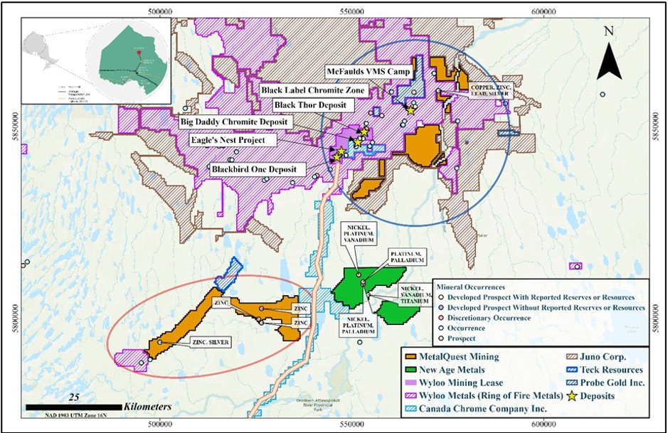
Figure 1: Location map showing the Fishhook Polymetallic Project (outlined in red) and the previously acquired ROF-1 Projects (outlined in blue) within the Ring of Fire geological corridor, Northwestern Ontario. The proposed Ring of Fire Road is shown as an orange line. The map also illustrates the relative position of nearby exploration projects and properties held by other operators for regional context.
Property Geology
The Fishhook Polymetallic Project is situated on the western margin of the Fishtrap Intrusive Complex, within a volcanic-intrusive belt considered prospective for both VMS and Ni-Cu-PGM mineralization. Helicopter-borne VTEM and magnetic surveys completed over the property by previous operators outlined numerous electromagnetic conductors associated with volcanic and intrusive rock units. A limited diamond drilling program completed in 2008 tested a subset of these anomalies and intersected widespread sulphide mineralization within bimodal rhyolite-basalt volcanic rocks.
Notably, drill hole FH-08-11 intersected approximately 20 metres of semi-massive to massive pyrite-pyrrhotite mineralization, interpreted by previous operators as a possible pyritic cap to a VMS system. Additional drill holes, including FH-08-05 and FH-08-07, intersected intervals of sulphide-bearing volcanic rocks with anomalous zinc values, while several other holes encountered disseminated to stringer-style sulphides over broad intervals. The majority of identified conductors and favourable stratigraphic horizons across the property remain untested by drilling, representing significant exploration upside.
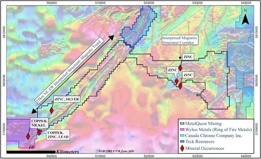
Figure 2: Property outline of the Fishhook Polymetallic Project overlain on Ontario Geological Survey (“OGS”) regional geophysical and geological datasets, including residual total magnetic intensity (RMI) aeromagnetic data (1:200,000 scale) and OGS Preliminary Map P.3806 (Precambrian geology of the McFaulds Lake area, Ring of Fire region — eastern sheet; Metsaranta & Houlé, 2017). Regional magnetic trends appear to extend beyond the Project boundary into neighbouring claim groups held by Wyloo Metals and Teck Resources. Interpreted geological features, including inferred lithological contacts, faults, and dyke trends, are derived from OGS regional interpretations and have not been independently verified by the Company.
Go-Forward Plan
MetalQuest intends to advance the Fishhook Polymetallic Project through a phased, data-driven exploration program focused on refining and prioritizing targets. Initial work will include the compilation and validation of historical geological, geophysical, geochemical, and drilling datasets, followed by reinterpretation of existing magnetic and electromagnetic surveys to improve structural and target models.
MetalQuest also plans to conduct targeted geological mapping, prospecting, and surface geochemical sampling to ground-truth interpreted features and identify priority zones. Results from these programs will be integrated to rank targets and design a staged drill program focused on the highest-priority anomalies.